
Forest and peat fires hitting Indonesia have turned the country into the world’s largest source of fire-related emissions this week. Data from the Copernicus Atmosphere Monitoring Service, cited by Reuters, indicate that the blazes released about 19.7 million metric tons of carbon dioxide between September 1 and 7.
The volume accounts for more than a third of global fire emissions during the period and placed Indonesia ahead of Russia. The estimate does not represent the country’s total annual greenhouse gas emissions: it measures only the carbon associated with the fires during the first seven days of September.
Smoke affects schools and health
The crisis has already surpassed environmental dimensions. The Associated Press reported that schools in parts of Sumatra and Borneo suspended in-person classes due to smoke and dangerous air quality. In Palembang, the capital of South Sumatra, students transitioned to remote activities as a protective measure.
The pollution generated by the fires contains fine particles capable of penetrating deep into the lungs. Children, the elderly, and people with respiratory diseases are among the most vulnerable groups. Local authorities recommended reducing outdoor activities and using proper protection in the most affected regions.
Drought and fires in peatlands
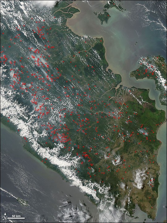
The intensity of the fires is fueled by extreme heat, prolonged drought, and conditions associated with El Niño. Kalimantan, on the island of Borneo, and eastern Sumatra concentrate a significant portion of the hotspots observed by satellite.
Peatlands worsen the problem because the organic material accumulated in the soil can burn beneath the surface. These fires are difficult to locate and extinguish, can remain active for long periods, and release large amounts of stored carbon.
According to data compiled by Reuters, recent emissions were 273% above the seasonal average. The number of hotspots recorded between August 1 and September 8 also surpassed those observed in the same timeframe in 2015, a year marked by one of the region’s worst smoke crises.
Regional impact
Wind currents can transport the haze to neighboring countries, increasing health risks and reducing visibility in Southeast Asia. The Indonesian government has stepped up firefighting operations and monitoring of critical areas, but the dry season could keep the risk high through October.
Copernicus tracks fires in near real-time through satellite observations and atmospheric models. Experts warn that estimates may be conservative when fires spread underground, as some peatland activity is harder to detect from space.
Air quality trends, the spread of the flames, and the resumption of classes will depend on weather conditions and the capacity to control hotspots. Meanwhile, authorities maintain health guidelines to reduce the population’s exposure to smoke.